
By Rocheford T. Gardiner

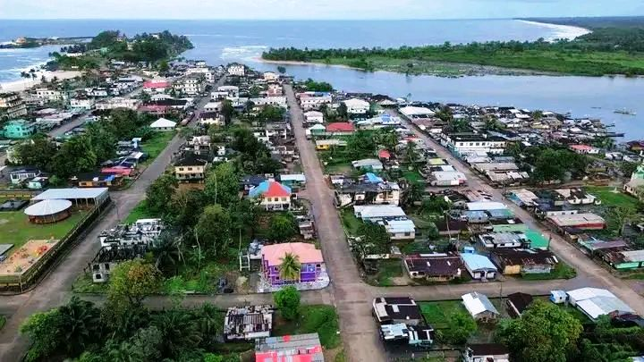
The coastal city of Harper, Liberia, perched on the jagged beauty of Cape Palmas, carries a history as layered as the rocks upon which it was built. While modern maps label the city “Harper,” its foundations rest upon a forgotten designation: Latrobe. This is the story of a man who built a city he never saw and a name that eventually faded into the salt air of the Atlantic.
The Visionary in Baltimore
The name “Latrobe” traces back to John Hazlehurst Boneval Latrobe, a man of significant American pedigree. The son of Benjamin Henry Latrobe—the architect of the United States Capitol—John H.B. Latrobe inherited his father’s penchant for design but applied it to a different kind of construction: the “building” of a nation.
As President of the Maryland State Colonization Society (MSCS), Latrobe was the primary architect of the “Maryland-in-Africa” project. He was a staunch advocate for a colony independent of the main American Colonization Society settlement in Monrovia. From his office in Baltimore, Maryland, Latrobe acted as a remote urban planner, drawing the original maps and layouts of Cape Palmas before a single settler had landed.
1834: The Birth of a Settlement
In February 1834, the ship Ann arrived at the rocky promontory of Cape Palmas. By decree of the MSCS Board of Managers, the specific residential and administrative hub on the Cape was named Latrobe.
At the time, a clear distinction existed between the two primary designations of the area:
- Latrobe: Specifically the rocky peninsula, housing the administrative offices, the lighthouse, and the residential core.
- Harper: Named after Robert Goodloe Harper, a Maryland politician and MSCS member who is credited with naming the country “Liberia” and its capital “Monrovia.” Harper originally referred to the broader township and the expanding inland farms.
The “Paper” City and its Realities

Latrobe was, in many ways, a “paper” city. John H.B. Latrobe managed the colonization effort for decades but never once set foot in Africa. He painted watercolors of the settlement based on letters and reports, often depicting Cape Palmas as a serene, tropical paradise.
However, the reality for the early settlers—and for the local Grebo people whose land was being settled—was far more complex. The “rocks of Latrobe” were the site of immense hardship, including:
- The Climate: High mortality rates due to malaria and yellow fever.
- Sovereignty Conflicts: Tensions with the Grebo Kingdom over land rights and trade, leading to several armed conflicts throughout the mid-19th century.
- Governance: The leadership of John Brown Russwurm, the first Black governor of the colony, who navigated the difficult path between the MSCS in Baltimore and the local reality.
The Vanishing Name

The name Latrobe persisted on maritime charts and official records for several decades. However, two major historical shifts led to its decline:
- Independence and Annexation (1854–1857): In 1854, Maryland-in-Africa declared independence as the Republic of Maryland. Just three years later, following a devastating war with the Grebo and Kru people, the fledgling republic sought annexation by the Republic of Liberia.
- Urban Expansion: As the settlement grew beyond the rocky Cape and merged with the inland areas, “Harper” became the administrative catch-all. By the late 19th century, Latrobe had been swallowed by the growth of the city.
Legacy on the Rocks
Today, “Latrobe” exists almost exclusively in the archives of the Maryland Historical Society. Yet, his influence remains visible. If you walk the streets of Harper today, the grid-like layout of the old town—the “architectural ghost” of a man 4,000 miles away—still dictates the flow of the city.
The name may have vanished, but the “rocks of Latrobe” remain the anchor of Maryland County, a silent witness to the ambitious, flawed, and fascinating dream of a Maryland in Africa.
Conclusion
Beyond its historical origins as Latrobe, Harper is defined by several landmarks that served as both physical and spiritual anchors for the early settlers and the sailors who braved the rocky Atlantic coast.
1. The Cape Palmas Lighthouse

The lighthouse is the literal and symbolic crown of the “rocks of Latrobe.” Standing on the highest point of the peninsula, it was crucial because the waters surrounding Cape Palmas are notoriously treacherous, filled with hidden reefs and strong currents.
- The Beacon: For nearly two centuries, it guided international trade ships and settlers’ vessels toward the harbor.
- A Strategic Point: During the 19th century, the lighthouse was not just a navigational aid but a signal of the colony’s presence to passing European and American ships. Today, while the original structures have been renovated or replaced over time, it remains the most iconic silhouette in Maryland County.
2. The Ever-Flowing Spring (Water from the Rock)
Located right on the rocky promontory, this natural freshwater spring is a geological marvel that played a vital role in the colony’s survival.
- The Lifeline: For early settlers, having a source of pure, “ever-flowing” freshwater directly on the rocky coast was seen as a divine blessing. It meant they didn’t have to travel far inland—where conflicts or disease might be more prevalent—to sustain the settlement.
- Significance to Sailors: Before modern desalination, freshwater was the most precious commodity at sea. Sailors would stop at Cape Palmas specifically to “water” their ships. The reliability of this spring made Harper a preferred port of call for the U.S. Navy’s African Squadron and merchant ships traveling down the West African coast.
3. St. Mark’s Episcopal Church

If the lighthouse was the city’s physical guide, St. Mark’s was its social and spiritual center. Established in the mid-1830s shortly after the colony’s founding, it is one of the oldest and most historic churches in Liberia.
- Architectural Heritage: Built with a distinct brick-and-stone style that mirrored the Maryland (USA) roots of its founders, the church stood as a testament to the “civilizing mission” the settlers believed they were undertaking.
- Social Hub: It wasn’t just for worship; it was the site of community meetings, school lessons, and political gatherings. Many of the prominent figures of the Republic of Maryland, including Governor John Brown Russwurm and early Liberian presidents from the region, were congregants here.
- Resilience: Despite the heavy damage sustained during the Liberian Civil War, the church remains a symbol of the resilience of the Harper community.
The “Remains of History”
Building on my discussion of Harper’s rich past as the “paper city” of Latrobe, here is a look at the current standing and significance of its three most defining landmarks.
1. The Cape Palmas Lighthouse: A Functional Relic
Standing at the very tip of the peninsula, the lighthouse remains the most recognizable feature of the Harper skyline.
- Current Status: As of early 2026, the lighthouse is a primary stop for history enthusiasts. While its full operational capacity as a modern navigational beacon has fluctuated due to the need for high-tech upgrades, the structure itself is a sturdy masonry tower. It is located near a UN base, and visitors often seek permission to climb its spiral stairs for a panoramic view of the Atlantic and the Hoffman River estuary.
- Symbolism: It remains so central to the identity of the region that it is officially inscribed on the flag of Maryland County, representing guidance and the maritime heritage of the “Sunshine County.”
2. The Ever-flowing Spring: Nature’s Engineering
The spring at the base of the “rocks” is one of the few places where history and geology remain unchanged since 1834.
- Significance: To early settlers and the Grebo people before them, this spring was a “miracle of the rocks.” In a tropical environment where standing water often bred disease, this filtered, flowing freshwater was life-saving.
- Modern Day: It is still a site of local wonder. For visitors, it serves as a tangible link to the settlers of the ship Ann, who relied on this exact source for their first drinks of water on the Cape. It stands as a reminder that the site for Latrobe was chosen not just for its defensive height, but for this specific natural resource.
3. St. Mark’s Episcopal Church: The Spiritual Anchor
Located on a prominent rise, St. Mark’s is more than just a building; it is a monument to the endurance of the community.
- Restoration: Having suffered significant damage during the Liberian civil wars, the church has undergone several phases of restoration. Today, it is an active parish and a member of the Episcopal Church of Liberia.
- Legacy: It continues to be a focal point for major historical commemorations in Maryland County. Its architecture—characterized by heavy stone and brick—reflects the 19th-century Maryland (USA) style that John H.B. Latrobe and the early governors like John Brown Russwurm envisioned for their new home.
These landmarks collectively tell the story of a city that was dreamed of in a Baltimore office, built by the sweat of pioneers, and preserved by the resilience of the people of Harper.
Acknowledgements: This research would not have been possible without the enlightenment of the following individuals (the two ladies are members of the “Cape Palmas Genealogy Project). Though through casual discussion, they opened my mind to lots of historical facts (with evidences) about the rich history of Maryland in Africa.
- Mrs. Gbuo Wilson Miller

2. Dr. Millie Brooks Peters


3. Eli Budu Tubman (RIP)